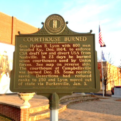
If your looking for several of the historical markers related to this area, you'll find several of them located in a park that's adjacent to the Taylor County Courthouse. The first historical marker that we want to feature is the Courthouse Burned historical marker #582. Here's what it says.
Gen. Hylan B. Lyon with 800 men invaded Ky., Dec. 1864, to enforce CSA draft law and divert USA from Nashville. In 23 days he burned seven courthouses used by Union forces. See map on reverse side. the courthouse at Campbellsville was burned Dec. 25. Some records saved. Desertions had reduced ranks to 250 and Lyon moved out of state via Burkesville, Jan. 3.
By: 1963 by Kentucky Historical Society & Kentucky Department of Highways.
History buffs are going to enjoy visiting these historical markers too! Here's some information about each one. They're all located within the park and within walking distance from one another. Several of the markers are double-sided, so make sure you read both sides!
Side 1
As early as 1779 and 1780, many settlers traveled over the trace, passing through what is now Taylor County. The Cumberland Trace branched off from the Wilderness Road near Logan's Station in Lincoln County (40 mi. east). It was the trail traveled by the pioneers who came through the Cumberland Gap to settle the then new lands of Ky. and Tenn.
Side 2
Turning west from Logan's Station, the trace crossed the Rolling Fork River; went down to Robinson Creek in what is now Taylor County; then near Buckhorn Creek, and down the south side of the Trace Fork of Sinking Creek (Pittman Creek). It crossed the Green River at Pittman's Station and went south across the Cumberland River to the site that is now Nashville.
By: 1970 by Kentucky Historical Society & Kentucky Department of Highways. This is historical marker #1383 for your documentation.
Gen. John Hunt Morgan's cavalry, returning from second Kentucky raid, here, Dec. 31, 1862. Took supplies. Went on to Tenn. On raid Union's rail supply line wrecked and $2,000,000 property destroyed. Morgan through here again after three hour battle at Tebb's Bend, July 4, 1863. Continued raid into Indiana to NE Ohio, where captured, July 26th. See map other side.
By: 1964 by Kentucky Historical Society & Kentucky Department of Highways. This is historical marker #706.
Side 1 (Shown Above)
Born 1763. Died 1843. Served in Rev. War from Culpeper Co., Va. His five brothers, Daniel, John, Joshua, Thomas and William, also served in Revolution. Elias Barbee came early to what is now Taylor County. Lived eight miles N.W. of Campbellsville. He was appointed Major in 1792, Colonel in 1797, and Brig. General, in 1799, in Ky. Militia, 16th Regt., Green Co., Ky.
Represented Green Co. in Kentucky Senate. In 1822, Senator Barbee introduced a bill in the Senate calling for the establishment of the present Kentucky School for the Deaf at Danville, KY. Bill drawn up by Judge John Rowan, passed by Legislature and signed by Gov. Adair, establishing on April 10, 1823, first state-supported school for the deaf in the United States.
By: 1975 by Kentucky Historical Society & Kentucky Department of Transportation. This is historical marker #1536.
First settled about 1800. Town, established by Legislature, 1817, was made seat of government when county was formed. It was named for Adam and Andrew Campbell who with three brothers came from Va., settling on father's land grants. Adam and Andrew among founders of town. Andrew died, 1819. Adam was prominent farmer and leader in Taylor County affairs.
By: 1966 by Kentucky Historical Society & Kentucky Department of Highways. This is historical marker #995.


No comments:
Post a Comment